

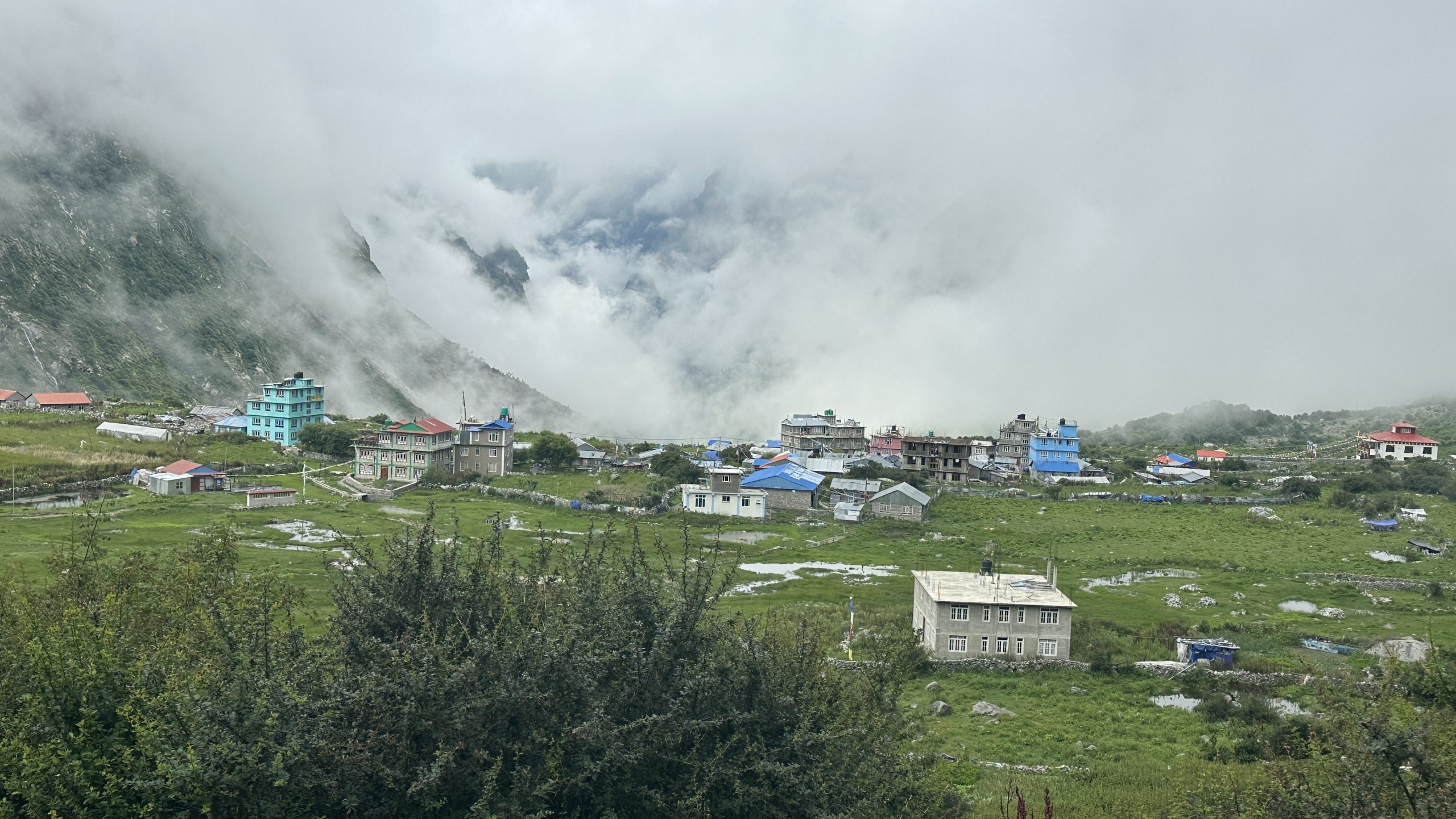
Langtang Valley Trek is a 8-day journey that starts in Syabrubesi and ends at Kyanjin Gompa, which is at a height of about 3,870 meters. This trek is good for people who’re new to hiking and are in good physical shape. The slow rise in height helps your body get used to the place gradually.
While you walk you will pass through forests, wide open fields, quiet mountain towns and see old Buddhist temples. The Langtang Valley Trek is not far from Kathmandu. Can be reached by car easily. This makes it a great option for travelers who want to see the Himalayas in a time.
Having a Langtang Valley Trek map helps you know where you are how far it is to the next place and what important spots are along the way. With the planning and the correct gear this trek can be a safe, fun and lasting adventure in the Himalayas.
In total the 8-day Langtang Valley Trek is an not too hard trip. It is perfect for people who’re new, to hiking and want to see the amazing mountains of Nepal the local way of life and the calm environment of the Himalayas.
Highlights
- Syabrubesi – Trek starting point
- Lama Hotel – Forested trail and riverside scenery
- Langtang Village – Traditional Tamang culture and mountain views
- Kyanjin Gompa – Main destination with spectacular Himalayan scenery
- Kyanjin Ri / Tserko Ri – Panoramic viewpoints of Langtang peaks
Map Overview
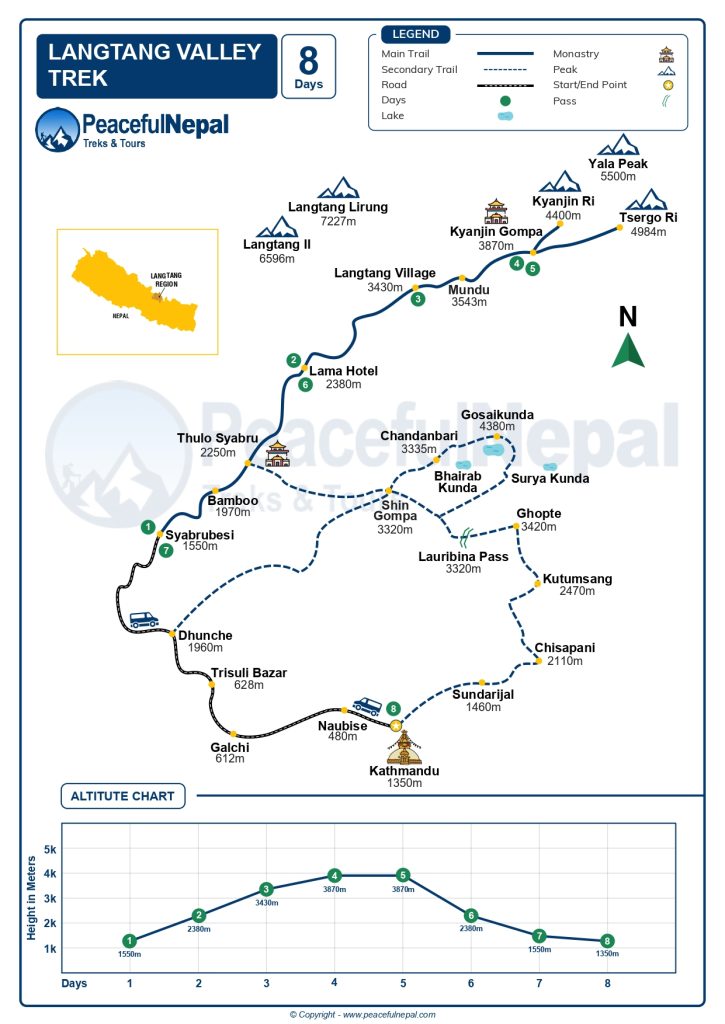
A Langtang Valley Trek map is a useful companion for anyone exploring this beautiful Himalayan region. It shows the main trail from Syabrubesi to Kyanjin Gompa, along with key villages, landmarks, and popular viewpoints such as Kyanjin Ri and Tserko Ri.
The map is especially helpful for planning each day of the trek. You can check walking distances, understand altitude changes, and get a clearer idea of the route through forests, mountain villages, rivers, and steep sections of the trail.
Beyond navigation, a good trek map helps you understand the entire journey before setting out. It gives you a better picture of the landscape and lets you plan your stops and side trips with confidence. For both first-time and experienced trekkers, carrying a Langtang Valley Trek map can make the adventure more organized, enjoyable, and stress-free.
Quick Fact
| Fact | Details |
| Region | Langtang, Nepal |
| Starting Point | Syabrubesi |
| Main Destination | Kyanjin Gompa |
| Starting Elevation | 1,460 m |
| Highest Trekking Point | Tserko Ri – around 4,984 m |
| Kyanjin Gompa Elevation | Around 3,830–3,870 m |
| Difficulty | Moderate |
| Trek Duration | 7–10 days |
| Best Seasons | Spring and Autumn |
| Popular Side Trips | Kyanjin Ri and Tserko Ri |
What Is the Standard Route on the Langtang Valley Trek Map?
The standard Langtang Valley Trek route shown on most maps follows a simple out-and-back trail. The journey starts at Syabrubesi and continues through Lama Hotel, Ghodatabela, Langtang Village, and Kyanjin Gompa before returning along the same route.
Some trekking maps also show alternative trails through Sherpagaon or Thulo Syabru. However, the main route eventually connects with Lama Hotel and then follows the river upstream through the beautiful Langtang Valley toward Langtang Village and Kyanjin Gompa.
From Kyanjin Gompa, trekkers can also take optional day hikes to Kyanjin Ri or Tserko Ri for spectacular mountain views. Depending on the itinerary, the trek usually takes around 7 to 10 days, with an extra day at Kyanjin Gompa often included for acclimatization and exploration.
Standard Langtang Trek Route
- Day 1: Drive from Kathmandu to Syabrubesi.
- Day 2: Trek from Syabrubesi to Lama Hotel.
- Day 3: Trek from Lama Hotel to Langtang Village.
- Day 4: Trek from Langtang Village to Kyanjin Gompa.
- Day 5: Optional hike to Kyanjin Ri or Tserko Ri and overnight at Kyanjin Gompa.
- Day 6: Trek from Kyanjin Gompa back to Lama Hotel.
- Day 7: Trek from Lama Hotel to Syabrubesi.
- Day 8: Drive back to Kathmandu, or stay an extra night in Syabrubesi if needed.
Mountain Views in the Langtang Region
- Langtang Lirung – 7,234 m (23,733 ft)
- Langtang II – 6,596 m (21,640 ft)
- Ganchenpo – 6,380 m (20,932 ft)
- Dorje Lakpa – 6,966 m (22,855 ft)
- Langshisha Ri – 6,427 m (21,085 ft)
- Yala Peak – 5,500 m (18,045 ft)
Best Season for Langtang Valley Trek with Map
The best times to go on the Langtang Valley Trek are spring and autumn. Spring runs from March to May. Autumn runs from September to November. During these times the weather is usually good the skies are clear. The mountains look amazing. The paths are also surrounded by nature, which makes the walk more pleasant.
Spring Season March May
Spring is one of the times to walk in the Langtang area. In this season rhododendrons start to flower. The forests are full of bright colors. The weather is usually nice the mountain views are clear. Many wildflowers make the path more attractive. With not hot or cold weather and nice views spring gives a trip that people will remember.
Autumn Season September November
Autumn is also a good time for the Langtang Valley Trek. After the rain season the skies are clear. The air feels fresh and calm. This time of year has some of the views of the big mountains. With weather, not too hot or cold and dry paths autumn is perfect, for walking in the Langtang area.
Is the Langtang Valley Trek Safe for Beginners?
Yes, the Langtang Valley Trek is a great choice for beginners. The trail is well-established, clearly marked, and easy to follow, passing through villages, forests, and beautiful mountain landscapes before reaching Kyanjin Gompa.
However, it still requires good preparation. You’ll walk around 4–6 hours per day on uneven and sometimes steep trails. Beginners should have a reasonable fitness level, prepare at least four weeks in advance, maintain a steady pace, and be aware of altitude sickness symptoms.
With proper preparation and acclimatization, beginners can enjoy the Langtang Valley Trek safely and comfortably.
Difficulty and Altitude Guide
The Langtang Valley Trek is one of Nepals rewarding Himalayan adventures with Kyanjin Gompa at 3,870 meters as its main destination. The altitude increases gradually along the trail giving your body time to adjust. With preparation and a comfortable walking pace the trek can be a great choice even for beginners.
The trek is generally considered moderate in difficulty. Although there are some uphill and downhill sections the trail is not extremely demanding. On days you can expect to walk for around 5 to 7 hours covering approximately 8 to 15 kilometers. Along the way you’ll pass through forests, open alpine meadows, mountain streams and traditional villages while enjoying beautiful Himalayan scenery.
The Langtang Valley Trek is ideal for travelers, with fitness who want to experience the Himalayas without taking on an overly challenging climb. Walking slowly taking rest and allowing your body to adjust to the increasing altitude can help reduce the risk of altitude sickness. With preparation this trek offers a wonderful mix of nature local culture and breathtaking mountain landscapes.
- Main Maximum Altitude: 3,870 m – Kyanjin Gompa
- Optional Highest Point: 5,030 m – Tserko Ri
- Starting/Lowest Altitude: 1,310 m – Syabrubesi area
Why Trek the Langtang Valley?
The Langtang Valley Trek is one of Nepal’s most rewarding Himalayan journeys, offering spectacular mountain scenery, rich local culture, and peaceful trails without the crowds found on some of Nepal’s more popular routes. Here are some of the main reasons to add Langtang to your trekking bucket list:
- Spectacular Himalayan Views: Enjoy close-up views of impressive peaks such as Langtang Lirung, Ganchenpo, Dorje Lakpa, and Langshisha Ri as you make your way through the valley.
- Rich Tamang and Himalayan Culture: Meet local Tamang and Sherpa communities and experience their traditional lifestyle, Tibetan-influenced culture, ancient monasteries, prayer flags, and local cuisine.
- Beautiful Nature and Wildlife: The trail passes through Langtang National Park, where you can walk through rhododendron and pine forests, alpine meadows, and diverse Himalayan landscapes. The region is also home to wildlife such as the red panda, Himalayan tahr, and musk deer.
- Moderate Trekking Difficulty: Langtang is considered a moderate-level trek, making it a great choice for trekkers who want a genuine Himalayan experience without the longer and more demanding routes of the Everest or Annapurna regions.
- Less Crowded Trails: One of Langtang’s biggest attractions is its peaceful atmosphere. The trails are generally quieter, allowing you to enjoy the mountains, villages, and natural surroundings at a more relaxed pace.
Conclusion
A map of the Langtang Valley Trek is really helpful. It makes the trip easier and more fun. The map shows you the way to go and where the important places are like villages and rivers. You can see the mountains and the beautiful fields. It also tells you how you are going to climb from Syabrubesi to Kyanjin Gompa.
If you have some time you can also go to Gosaikunda Lake. This is a pretty place and many people like to go there. It is near the Langtang Valley Trek. Looking at the map before you go helps you plan where to stop and rest. You can see where the road is very steep and get ready for the mountains.
Having a map makes you feel safer and more confident. It makes your trip, to the Langtang Valley Trek more fun. Something you will always remember.
FAQ’s
How Do I Get to the Langtang Trek Starting Point?
The Langtang Valley Trek usually begins with a scenic drive from Kathmandu to Syabrubesi, which takes around 7–9 hours depending on road and weather conditions.
Can You Start the Langtang Trek from Dhunche?
Yes, Dhunche can also be used as a starting point, particularly for trekkers combining the Langtang Valley with the Gosaikunda Trek or Tamang Heritage Trail. However, Syabrubesi is the most common starting point for the classic Langtang Valley Trek.
Where Can You Stay During the Langtang Valley Trek?
Teahouses and lodges are available along the Langtang Valley Trek route. Most are family-run and provide comfortable rooms, shared bathrooms, and freshly prepared meals. Popular overnight stops include Syabrubesi, Lama Hotel, Langtang Village, and Kyanjin Gompa.
What Permits Are Required for the Langtang Trek?
Trekkers generally need a Langtang National Park entry permit and a Trekkers’ Information Management System (TIMS) card. Permit requirements can change, so it is best to check the latest regulations before starting the trek.
Is There Mobile Network and Wi-Fi on the Langtang Trek?
Mobile coverage and Wi-Fi are available in some villages, but the connection can be unreliable at higher elevations. It is a good idea to inform family or friends before leaving and carry a power bank for your devices.
What Should I Pack for the Langtang Valley Trek?
Essential items include comfortable trekking boots, warm layers, a waterproof jacket, sleeping bag, trekking poles, water bottle, sunscreen, headlamp, and basic personal medicines. Your packing list should also vary according to the season.
Posted on